Before October of 2011, oil drilling—in American waters of the Gulf of Mexico—was managed by a federal agency known as Minerals Management Service (MMS). That federal agency was replaced by the Bureau of Safety and Environmental Enforcement (BSEE) on October 1, 2011.
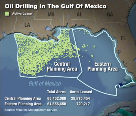
Part of the area managed by the MMS/BSEE is the "Central Planning Area" of the Gulf. It is located south of the Louisiana and Alabama shoreline, and encompasses 66,452,086 acreas.
Before October of 2011, a company wanting to drill for petroleum in the Gulf first had to obtain a lease from MMS. In 2008, when this map was created with data released by that agency, nearly half of the Central Gulf—28,875,454 acres—was under lease to various companies.
Media Credits
Image created by Alice Kreit, of National Public Radio, using data from Minerals Management Service, Department of the Interior. Image online, courtesy NPR.


